Mitú
Mitú is the capital of the department of Vaupés, where 27 different indigenous ethnic groups predominate. Mitú is characterized by being a municipality of transition between the dry plains of the Orinoquía, and the humid Amazon rainforest. Its temperatures range between 25 and 30 °C.
«Mitú» means «paujil», or «wild turkey» in Yeral language (the Tupi-Guaraní language that Portuguese colonizers promoted as a lingua franca in the region).
There are no natural parks, but it should be noted that the municipality in its entirety is part of the Amazon forest reserve declared by law 2 of 1959 and to date the corresponding area to the urban sector of Mitú has not been subtracted.
Due to the fact that practically the entire territory is forested, there are no forest remnants, much less planted forests.
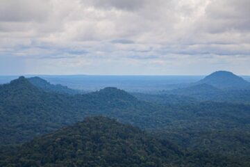
The following hills stand out in the municipality although their heights range between 100 and 300 m above sea level, they are scattered hills, with rounded termination and in most cases without vegetation, composed of Precambrian crystalline rocks, with granitic textures. These are the most outstanding: Guacamayas, Pringahermosa, Pirapuku, Santa Lucía, Peña de Guamoya, Avina, Pedo de la Guacamaya, Tui, Utura, Cacuri, Pecu, Banco de Tigre, Banco de Morroco and Trueno.
The Guacamayas hill, visible to the south of the municipality, is one of the closest, easily accessible from the municipal seat and accessed by sandy and humid routes; for the most part it is steep with large inclinations and some vegetation.